


| GeoMundus 2013; Castelló de la Plana, Spain; November 15-16 2013; Venue: Universitat Jaume I, ESPAITEC 2 | ||
| Please remember that there is an informal gathering on Thursday November 14th at 19:30 at Las Tascas area | ||
| Friday November 15th 2013 | ||
| Time | Sessions | Author/Info |
| 09:00 | Open Doors: Conference Registration | |
| 9:30 - 10:00 | Welcome Speech: Conference Chair, student representative (conference team), Dr. Joaquín Huerta Guijarro (UJI Erasmus Coordinator), Prof. Dr. Inmaculada Fortanet-Gómez (UJI Vice-Rector for Cooperation and International Relations) and Amichai Korda (Student's representative) | |
| 10:00 - 10:45 | Keynote Speech 1: Prof. Dr. Gilberto Camara | Personal page @ INPE (National Institute for Space Research, Brazil) |
| Open source geospatial software and open geospatial data: What changes in institutions and academia? | TBA | |
| 10:45 - 11:15 | Coffee Break | |
| Scientific Session 1* | ||
| 11:15 - 11:40 | Location integration into the crisis management lifecycle |
Luis Bausá López, Vrije Universiteit Amsterdam, The Netherlands |
| 11:40 - 12:05 | Campus map of UNL campus of Campolide - An interactive approach using open source software |
Colin Broderick, Karina Popova, Miguel Carrilho, Yasmine Megahed Instituto Superior de Estatística e Gestão de Informação (ISEGI), Univeridade NOVA de Lisboa, Portugal |
| 12:05 - 12:30 | Analysis of urban expansion in the north region Fluminense between the years 1994 and 2007 using census data and remote sensing |
Daniel Carlos Machado Instituto Superior de Estatística e Gestão de Informação (ISEGI), Univeridade NOVA de Lisboa, Portugal |
| 12:30 - 14:15 | Lunch break | |
| 14:15 - 15:00 | Keynote Speech 2: Manuel Madrid | gvSIG Association, Spain |
| The growth of Open Source movement and future challenges for open source GIS: the case of gvSIG project | In this presentation Manuel will firstly introduce the Open Source movement, clarifying the main concepts around it (terminology, licenses, myths, business model etc.) and role of the FOSS4G and OSGeo Foundation. Finally he will talk about the origin, evolution and future challenges of the gvSIG project, which is a successful case of a free open source GIS software project. | |
| Scientific Session 2* | ||
| 15:00 - 15:25 | Development of a prototype for spatial decision support system in risk reduction based on open-source web-based platform. | Roya Olyazadeh; Zar Chi Aye; Michel Jaboyedoff
University of Lausanne, Switzerland |
| 15:25 - 15:50 | Tobler's law in electoral geography: General elections in Canada | Alexey Yeskov, Universitat Jaume I, Spain |
| 15:50 - 16:15 | Coffee break | |
| 16:15 - 17:15 | Career Development Session: Daniel Gastón (Prodevelop) and Frank Holsmuller (ESRI) | |
| 17:15 - 17:30 | Organisational announcements | |
| 21:00 | Conference Dinner | Bocatería Panetto |
| Saturday November 16th 2013 | ||
| Time | Sessions | Author/Info |
| 09:30 | Open Doors | |
| 10:00 - 10:45 | Keynote Speech 3: Dr. Andrew Hill | |
| The power of storytelling for GIS experts |
Storytelling is the most important tool you will use to share the knowledge you create. While you spend your time refining GIS skills and your ability to use the tools of our community, what you may not realize is that you are becoming an expert at identifying stories in data, data that alone are all but meaningless to the rest of the world. Make it your mission to tell good stories with data and you will become an invaluable contributor in your future collaborations. This talk will explore how open source tools, modern web technologies, and a diverse mapping and GIS community are changing the way we present and communicate geospatial data. |
|
| Scientific Session 3* | ||
| 10:45 - 11:10 | From a nowcast-forecast information system to an oil spill risk assessment and response tool | Gonçalo Jesus, Hydraulics and Environment Division, Laboratorio Nacional de Engenharia Civil, Portugal |
| 11:10 - 11:35 | New methods for old hypotheses: testing gentrification in Newcastle-Gateshead using open source GIS | Jairo Matallana Villareal, University of Kent (UK) / ELTE University (Hungary) |
| 11:35 - 12:00 | SDAR - A new quantitative toolkit for analyzing stratigraphic data | John Ortiz, Smithsonian Tropical Research Institute (Panama) / ISEGI, Universidade NOVA de Lisboa (Portugal) |
| 12:00 - 12:30 | Coffee Break | |
| 12:30 - 13:15 | Keynote Speech 4: Dr. Alan Glennon | Universidade NOVA de Lisboa, Portugal |
| Experiments in Geospatial Optimization |
Geospatial optimization considers the problem of balancing objectives and constraints in spatiotemporal resource allocation. People continuously encounter such problems in achieving goals related to position (e.g., prime location), navigation (e.g., choice path), and arrangement (e.g., best configuration). In some respects, traditional GIS functionality mimics the naïve heuristics and often-incomplete information used for such decision making; that is, GIS affords satisficing instead of optimality. Better computers, data, and solution algorithms make more sophisticated approaches to geospatial problems possible. Combining geospatial data with analytical strategies from operations research, network analysis, and graph theory offers new tools for spatial problem solving. An example use case involves tourist routing; itinerary creation requiring balancing objectives and constraints generally is an ill-suited problem for a GIS. Framed as an optimization problem however, a logical workflow can be instantiated using open source software. While a vast amount of work has been conducted, particularly in the field of location science, an ongoing opportunity exists to inventory and categorize optimization workflows in a geospatial context. |
|
| 13:15 - 14:00 | Special Guest: Pedro-Juan Ferrer Matoses | Curriculum Vitae |
| The Open Source Geospatial community | In this talk the presenter will explain what is the Open Source Geospatial Foundation (OSGeo), where does it comes from, and its main activities. The OSGeo Foundation has been leading the development of free geospatial software for the last seven years, providing an umbrella for many projects, big and small, from map servers to web-mapping libraries or metadata catalogues. But beyond the software development infrastructure, OSGeo is a big community of developers, power users, documenters, translators, advocates, project and company managers and enthusiasts of the geospatial open source software. |
|
| 14:00 - 15:00 | Lunch Break | |
| 15:00 - 17:00 | Parallel Workshops | |
|
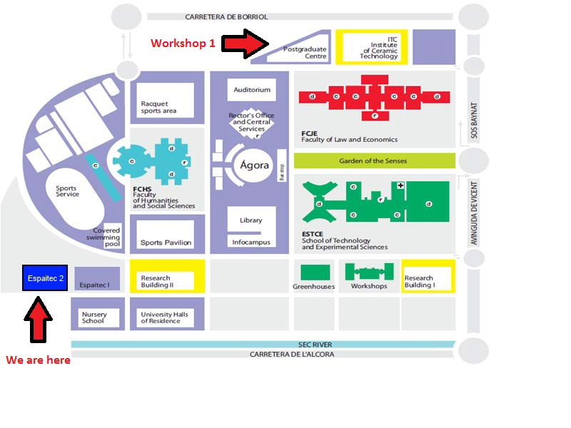
Workshop 1: "Android programming on mobile platforms”, led by Luís Rodríguez and Diego Gargallo Tarín (Universitat Jaume I) The idea is to get into the principles of android mobile applications development, we will develop a very simple mobile app with basic GIS functionalities by using the Google API. At the end of the workshop the participants will be able to develop their own mobile app. Prerequisites:
Location: Post-graduate building, 2nd floor - Lab 203. See the map here. |
||
|
Workshop 2: ''Creating Smart Campus basemaps and building functionality'', led by Ana Sanchis Huertas (Universitat Jaume I). Location: Espaitec II, 2nd floor |
||
| 17:15 - 17:30 | Closing Session | |
| 20:00 | Informal dinner (self-financed) | |
| *each paper presentation will take around 25 minutes (including Q&A) | ||
Organizing Committee and collaborators
Steering team:
- Elisabet Adeva Romero
- Amichai Korda
Web team:
- Nadal Francisco Garcia
- Mijail Naranjo Zolotov
- Hernán Cortes Rodriguez
- Constancio Amurrio García
- Nemanja Kostic
- Arfanara Najnin
- Atalel Getu
- Juan López Roca
- María del Pilar Reyes Careaga
- Alexey Eskov
- Alex Soloviov
- Arturo Torres
- Dori Apanewicz
- Muhammad Amin Khan, EMA
- Vera Lucia Guimaraes Camara


